The 2022 IGS Datum Modernization of the NSRS


Vertical Datum
The mid-20th century experienced various changes to the science of geodetic leveling, or the process of determining elevations above mean sea-level. Changes included a widespread multi-agency effort to collect terrestrial gravity measurements, development of new corrections to leveling, and a deeper understanding of the differences between local mean sea level (LMSL) at disparate tide gages all contributed to the questioning of the National Geodetic Vertical Datum of 1929 (NGVD 29). Those scientific developments, as well as the 625,000 kilometers of leveling that were performed post-NGVD 29, were used to create NAVD 88.
NAVD 88 was an improvement over the 1929 datum, with 100,000 benchmarks growing to 450,000 and leveling numbers going from 102,724 kilometers to 1,001,500 kilometers. However, it hasn’t been readjusted since its implementation. According to Smith’s white paper, some localized leveling allowed original heights to be superseded, while in some cases, like the state of Louisiana, a number of questionable heights were removed in favor of updated leveling and GPS-based heights. NAVD 88 holds a single point (Father Point, in Rimouski, Canada) as its fixed point. Without an active maintenance plan or any consideration for readjustment, regional distortions impact its value.
Smith goes on to mention six major issues with NAVD 88, which warrant its replacement in 2022. Those issues include:
- Cross-country accumulation of errors from geodetic leveling;
- Fragility and location of passive monuments;
- Bias in the NAVD 88 H=0 reference surface compared to the geoid;
- Subsidence, uplift, and other crustal motions of the Earth;
- Sea level changes; and
- Changes to Earth’s gravity field.
As a result of those problems, coupled with issues surrounding the nature of a passive-monument-based system of vertical geodetic control in general, NGS created and released its 10-year plan.
While the error in horizontal coordinates is concerning, a vertical error is just as problematic. Smith points out that it is important to consider one of the most fundamental height equations of geodesy, which converts the ellipsoid heights (h) as derived from GPS into orthometric heights (H), as used on topographic maps, through a model of geoid undulations (N). That equation is: H = h – N.
Currently, in NAVD 88, this equation is incorrect by a few meters, due to errors in the orthometric heights and a tilted set of systematic errors in ellipsoid heights. This error ranges from 1.5 meters in Florida to 0.3 meters in the Pacific Northwest. To “close” the earlier equation, NGS has produced a “hybrid geoid” model, (N*). With that modification, the equation reads: [H + systematic errors in NAVD 88] = [h + systematic errors in NAD 83] – N*. This is a prime example of why NGS is replacing both the NAD 83 datum and the NAVD 88 datum, because they are so closely intertwined.
As previously discussed, NAVD 88 is realized through geopotential numbers and orthometric heights at hundreds of thousands of passive geodetic control monuments across North America. These numbers were computed through an adjustment of geodetic leveling, holding the single fixed point of Father Point/Rimouski. While this removed the warping found in NGVD 29, it introduced the potential for an accumulation of systematic errors.
Observational errors account for some of these issues, but theoretical errors, such as the formulae used to convert leveled height differences into geopotential numbers in mountainous terrain, are also to blame. Such errors (a combination of leveling, geoid modeling, and VLBI errors) marked discrepancies in the -105 to +76 centimeter range at various locations around the country.
Another estimate of error accumulation from leveling was performed in 2004 (Wang, et al, 2004). This estimate used NAVD 88 heights, co-located with GPS-derived ellipsoid heights, and a long-wavelength geoid model, completes the Gravity Recovery and Climate Experiment (GRACE). Spatial filtering of the leveling and GPS data to the wavelengths offered by GRACE removed any of the localized issues and allowed for a continent-wide view of the discrepancies. Because of the high accuracy of the data from both the GPS and GRACE (usually found in the 1 to 3 centimeters range) any significant inconsistencies could be identified as an error in NAVD 88.
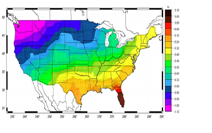
Image excerpted from the white paper by Dr. Dru Smith, called “Improving the National Spatial Reference System”
A figure of the error accumulation of NAVD 88. They range from about 16 cm in Florida to -112 cm in the Pacific Northwest.
It is important to note that the errors seen in Photo 4 don’t correlate with the distance from Father Point. This is a prime indication of the complex nature of the issue, and displays the difficulty of expecting the standard error model of geodetic leveling to yield true error estimates cross-continent.
When performing the constrained adjustment that ultimately led to NAVD 88, the choice was made to hold the LMSL height as “fixed” at the Father Point. That choice, however, was not made because of a particular closeness of LMSL to the geoid at that point. It was made to minimize the effects on national mapping products as requested by users. Because those products, relative to NGVD 29, existed in paper form, choosing a new datum that aligned well with that eliminated significant map recompilation efforts. The final bias between Father Point and the actual geoid remained as something of an indeterminate quantity due to the lack of good geoid modeling at that time. There have been attempts to rectify that bias, but the most recent estimate of the bias in the NAVD 88 reference system, which used a GRACE-based geoid model, was approximately 50 centimeters. That is , the difference between a true orthometric height and a NAVD 88 height is, on average, about a half-meter.
NAVD 88 was intended to provide orthometric heights to users referred to as “heights above mean sea level.” However, these orthometric heights are scientifically defined as heights above the geoid, as sea level doesn’t technically exist anywhere but the sea, and the geoid is the surface of equal gravity potential energy. What is critical here is the question of how the geoid changes as sea level changes. Sea level is rising each year on a global scale, so this change must be taken into account. Even though NAVD 88 is tied to LMSL at Father Point, no attempt has been made to update it based on a changing LMSL.
Similarly, the Earth’s mass are constantly in flux as well, which affects the gravity field and subsequently the geoid. According to Smith, based on the definition of orthometric height, geoid changes should result in corresponding orthometric height changes. But, this is not accounted for in NAVD 88.
The fragility and location of NAVD 88’s passive monuments are also important to note. Thousands are lost each year. Many are located alongside highways and roads, which allows easy access and a good stretch for leveling. However, any construction project or accident can result in the removal of a huge number of bench marks.
Tying into that movement of passive marks is subsidence, or the gradual caving in or sinking of an area of land. As Smith says, the purpose of geodetic control is providing an accurate starting height for surveying and mapping, so the unrecorded movement of a passive monument set in a subsiding crush comprises the intention of the monument. This is compounded when decisions are made based on monuments that are set in these deteriorating crusts. This can lead to unintentional harm to lives or property, such as building homes in flood prone areas or roads being incorrectly declared high enough to serve as evacuation routes. Inaccurate heights, in those instances, could be devastating.
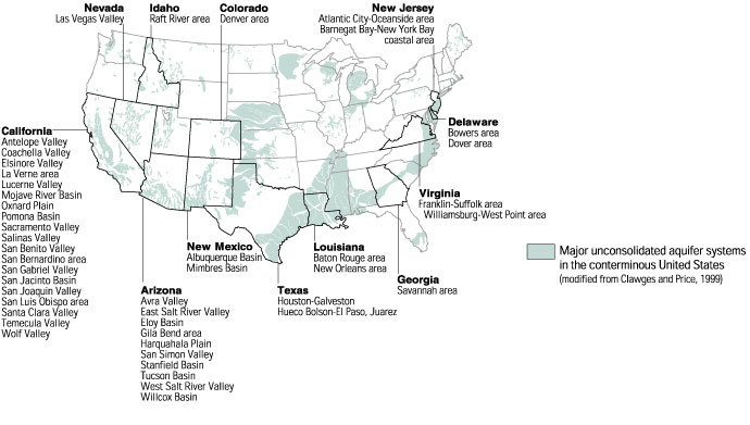
Image excerpted from the U. S. Geological Survey website
This map shows some of the areas where subsidence has been attributed to the compaction of aquifer systems throughout the U.S.
