The 2022 IGS Datum Modernization of the NSRS


North American Vertical Datum
Objective two of the second goal states that, by 2022, the National Geodetic Survey aims to reduce all definitional and access-related errors in orthometric heights in the geopotential reference frame to 2 centimeters when using 15 minutes of GNSS data. Similar to objective 1, this is nicknamed, “Replace NAVD 88.”
The North American Vertical Datum of 1988 requires improvements in both definition and services provided in order to access it. Definition-wise, NAVD 88 has a bias of half-a-meter and a 1 meter tilt. And to access it appropriately, users must collect hours of GNSS data or rely on decades-old heights. As the plan states, vertical motion is not tracked in any sort of systematic way.
The NGS will be implementing the National Height Modernization Program (Height Mod) in order to help accomplish this objective. This program was used previously to improve access to NAVD 88 by using GNSS to establish orthometric heights. The program’s effectiveness has improved the hybrid geoid model, as it has also grown to support the Gravity for the Redefinition of the American Vertical Datum (GRAV-D) project, which will be instrumental in replacing NAVD 88.
The NGS will be combining improvements in all of these areas, to prepare for the replacement of NAVD 88 with a four-dimensional geopotential field capable of describing heights, deflections, and other aspects of the gravity field surrounding Earth’s surface. One challenge the NGS will attempt to solve during this redevelopment is developing a comprehensive strategy for incorporating past and future leveling data into a GNSS/geoid-based vertical datum, as well as ensuring an actual connection to the NSRS with charting data. Objective three of the 10-year NGS plan is to increase the efficiency and accuracy for soliciting, accepting, storing, etc., the results of all survey data, while maintaining the high standard of quality that is expected.
The Need to Modernize
The decision to modernize the datums has been evolving over time. The NSRS, though satisfactory to most current geospatial user requirements, has its shortcomings. To fulfill its mission of providing the geodetic reference frame for any and all United States geospatial activities, NGS must be as scientifically accurate as possible. Because of that, it was determined that they must address the serious issues of inaccuracy in the realizations of both NAD 83 and NAVD 88.
The North American Datum of 1983 (NAD 83) has a known non-geocentricity of 2.2 meters, relative to today’s knowledge of the geocenter. That means it is misaligned with the primary global GNSS reference frames and antenna models.
According to a poster created by William A. Stone and Dana J. Caccamise II called “Pathway to 2022: The Ongoing Modernization of the United States National Spatial Reference System,” which was presented at the American Geophysical Union fall 2017meeting, recent realizations in both 2007 and 2011 of NAD 83 attempted to bring the episodically occupied passive geodetic control network of 80,000 stations and the nationwide GNSS CORS network of 2,000 stations into a state of consistency. This effort was complicated by the vastly differing nature of these passive and active networks. The solution lies in the CORS network, which helps define the modernized geometric references frames and facilitates their access.
North American Vertical Datum of 1988 (NAVD 88) has a bias of 0.5 meters and a tilt of 1 meter coast-to-coast in its zero-elevation definitional surface relative to today’s global mean sea level.
These issues arise from the fact that both datums are largely defined by a nationwide network of passive geodetic survey monuments and terrestrial surveying techniques, which have been surveyed over many decades and are subject to degradation, deterioration, and movement, both physically and through simple removal. Another issue is the lack of resources available to maintain them. Thus, the datums have become unsustainable.
The NGS is working on defining and adopting a geocentric reference datum to replace NAD 83, and working to compute an accurate geoid model to serve as the defining surface of a new vertical datum through GNSS technology to replace NAVD 88.
Horizontal/Geometric Datum
In the 1950s, horizontal datums were met with the use of electronic distance measuring equipment, which helped NGS discover and quantify local and regional distortions in the North American Datum of 1927 (NAD 27) and led to its replacement with NAD 83. As NAD 83 was starting to come into realization, modern space geodetic techniques like very-long-baseline interferometry (VLBI), satellite laser ranging (SLR), and the Global Positioning System (GPS) were introduced.
Over time, the NGS needed to fix the various local and regional distortions of the newly adopted datum, just as it had with NAD 27. They conducted state-by-state GPS surveys, referred to as the high accuracy reference networks (HARNs), to improve the latitude and longitude accuracy on passive control points. A second round followed to determine accurate ellipsoid heights because height determination methods had improved post-HARN.
This information fueled a massive readjustment called NSRS2007, which sought to improve nationwide consistency and accuracy by removing state-to-state coordinate inaccuracies, according to a white paper by Dr. Dru Smith, chief geodesist, NGS, called “Improving the National Spatial Reference System White Paper, 2010.” While the readjustment was somewhat successful, it didn’t resolve every problem and was only applicable to about 70,000 passive monuments in North America.
At the time of the first realization of NAD 83, the only space geodetic data available was Transit Doppler observations, which had an unexpected uncertainty of about 1 meter. Latitudes and longitudes were geodetic, and lacked the techniques needed to determine the geocenter of the Earth. As GPS and SLR data became more readily available and ultimately combined with other space geodetic techniques creating the International Terrestrial Reference Frame of 1988 (ITRF88), knowledge of Earth’s geocenter to the sub-decimeter level developed. When the 3D coordinates were compared, it was discovered that NAD 83 had a non-geocentricity of over 2 meters (2.209 meters). Following this realization, an official transformation between NAD 83 and ITRF96 was adopted by the NGS and the Geodetic Survey Division, Natural Resources Canada (formerly Geomatics Canada), which defined the official origin offset between the two frames.
A 2-meter non-geocentricity, which manifests itself as height errors of ± 2 meters (globally), will produce significant errors for users. According to Smith, this creates a roadblock of improving accuracy by causing inconsistency between national mapping products and GNSS positioning; forcing a biased and tilted inconsistency in national geoid products; causing confusion and inconsistency by mixing height systems when measuring sea level change; and causing an inconsistency between the national coordinate frame and that of other countries.
Along with the problems of using a non-geocentric reference frame, NAD 83 also suffers from inconsistencies between coordinates of the CORS network and passive marks, and has a lack of velocities on passive control used to realize the datum.
Because the Earth is a dynamic entity, it is consistently shifting, with geodetic control in constant motion and coordinates continually changing. This was not a problem in the past because measurement errors exceeded the magnitude of the motion. The current network of GPS sites and real time networks worldwide mean differential accuracies of a few centimeters are achievable. Relying on outdated coordinates on a passive monument causes inconsistencies between maps and coordinates calculated using GPS.
In his white paper, Smith mentions an example of this: a readjustment of all available GPS data observed on passive monuments in the United States called NSRS2007, which was designed to reconcile GPS vectors through a 15-year time span to a common epoch. However, a variety of issues prevented consistency between CORS and NSRS2007 including a lack of accounting for the vertical motion of passive monuments.
The new realization of NAD 83 would potentially address where the velocities of the passive monuments would be estimated, rather than solving for the set and stagnant coordinate.
Terrestrial Reference Frames
With additional Global Navigation Satellite Systems (GNSS) beyond the original GPS, users have access to positioning tools that can achieve sub-meter accuracy. When this sub-meter accuracy occurs, a horizontal discrepancy in the national datum of 2 meters will cause problems. Smith notes, maps of roads in the United States may have NAD 83 coordinates, but personal navigation units work in the World Geodetic System of 1984 (WGS 84) which is geocentric to within a few centimeters. In such a scenario, comparing the WGS 84 coordinates of the car to the NAD 83 coordinates of the mapped roads will mean up to 2 meters of error that could cause issues and incorrect determinations.
The geometric component, or the latitude, longitude and ellipsoid height, of the modernized NSRS that will replace NAD 83 will come use four CORS-based terrestrial reference frames. Those four frames include the North American Terrestrial Reference Frame of 2022 (NATRF2022), the Pacific Terrestrial Reference Frame of 2022 (PTRF2022), the Caribbean Terrestrial Reference Frame of 2022 (CTRF2022), and the Mariana Terrestrial Reference Frame of 2022 (MTRF2022). They are all effectively fixed and pertinent to a specific tectonic plate, and will be identical to the 2022-current International GNSS Service (IGS) global reference frame at a specified epoch.
Five sets of curvilinear geodetic coordinates, including geodetic latitude, geodetic longitude, and ellipsoid height, will come from these sets of Cartesian coordinates.
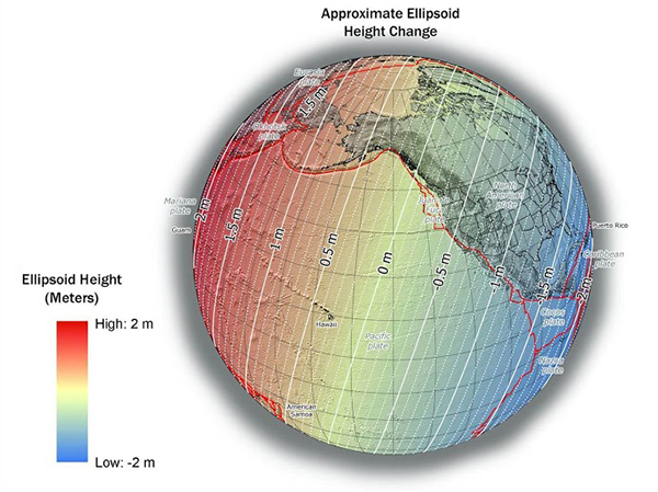
Image excerpted from the National Geodetic Survey website
The approximate ellipsoid height change
According to the Stone and Caccamise II poster referenced earlier, at any other epoch, each of the four terrestrial frames will relate to the IGS global frame through the definition of an Euler Pole location and rotation rate, which will be determined and analyzed by historical CORS data.
All CORS horizontal velocities that deviate from rigid plate rotation, meaning they’re not captured in the Euler Pole model, as well as vertical motions, will be incorporated into a residual intra-frame 3D velocity model. This model will allow users to compare time-dependent coordinates in any of the four terrestrial reference frames at any epoch. The intra-frame 3D models will assist geospatial professionals in proactively using a highly accurate spatial framework, while mitigating the impact of tectonic motion on accurate positioning.
An update of the State Plane Coordinate System (SPCS) will also be part of the transition from NAD 83 to the 2022 Terrestrial Reference Frames, with each state having the opportunity to update their State Plane Coordinate System zones. NGS will replace SPCS 83, which was referenced to NAD 83. Details on the process for making requests and proposals for SPCS2022 will be available from NGS.
