The 2022 IGS Datum Modernization of the NSRS


Learning Objectives:
- Describe the history and structure of the National Spatial Reference System (NSRS).
- Explore the changes being put in place by the National Geodetic Survey in their 10-year plan.
- Identify what will occur to the National American Datum of 1983 (NAD 83) and the North American Vertical Datum of 1988 (NAVD 88).
- Summarize the impact the changes will have for professional land surveyors and geospatial researchers.
Credits:
As an IACET Accredited Provider, BNP Media offers IACET CEUs for its learning events that comply with the ANSI/IACET Continuing Education and Training Standard.
This course may qualify for continuing education through the FBPE.
This course may qualify for continuing education through the NYSED. For further information, please visit the NYSED website at http://www.op.nysed.gov/prof/pels/peceques.htm.
The new geometric datum will change latitude, longitude, and ellipsoid height by 1 to 2 meters. New vertical datum will change heights, on average, by 50 cm, with a 1-meter tilt towards the Pacific Northwest.
Underlying Issues
Global Navigation Satellite Systems (GNSS) have taken a major role in geolocation. The underlying reference frames for all GNSS systems rely on egocentricity, the measurement from the center of the Earth. The International Terrestrial Reference Frame (ITRF) has gotten more geocentric over the years, resulting in the origin of the ITRF coinciding with Earth’s center to about 1 centimeter of accuracy. In the United States, the National Spatial Reference System (NSRS) is the official coordinate system for all geospatial activities. Two of the datums that make up the NSRS, the North American Datum of 1983 (NAD 83) and the North American Vertical Datum of 1988 (NAVD 88), were created with old survey techniques that aren’t incredibly reliable or relevant with the advent of GNSS.
Because of this, NAD 83 and NAVD 88 have each been recognized as having systemic errors. These include NAD 83 being non-geocentric by about 2 meters, and NAVD 88 being biased by about a half-meter and tilted by about 1 meter coast-to-coast.
These issues stem from both datums being created using terrestrial surveying techniques at passive geodetic survey marks, which tend to deteriorate over time or suffer from physical movement. They also don’t take into account that Earth’s masses are in a constant state of flux. While there have been improvements over the years, they’ve been restricted to adjusting subsets of coordinates within the datum rather than replacing the datum itself. Therefore, the NGS has identified that these problems will be best addressed by defining and creating new horizontal and vertical datums. In 2022, the NSRS will consist of four terrestrial reference frames and one geopotential datum.
This course will look at the National Geodetic Survey’s decade-long effort to prepare and modernize the National Spatial Reference System and its user community, which will include the approximate replacement of all the components of the U.S. national geodetic datums and models in 2022. These include the National American Datum of 1983 (NAD 83) and the North American Vertical Datum of 1988 (NAVD 88). The course will also explain the long-term impact for the land surveying and geospatial professions. It will also cover how best to prepare for the impending changes, and how to move forward.
The History of the NSRS
The National Spatial Reference System is, according to the National Oceanic and Atmospheric Administration’s National Geodetic Survey, a consistent coordinate system that defines latitude, longitude, height, scale, gravity, and orientation throughout the United States.
The NSRS uses a network of continuously operating reference stations (CORS) to support three-dimensional positioning activities. It also includes a network of permanently marked points; an accurate national shoreline; and a set of models describing geophysical processes that affect spatial measurements.
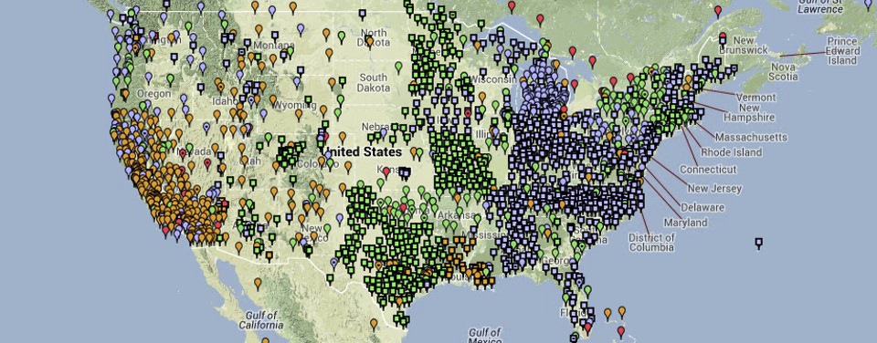
Image excerpted from the National Oceanic and Atmospheric Administration website
The NSRS includes a network of continuously operating reference stations (CORS) supporting three-dimensional positioning activities (shown here).
For more than 200 years, the NGS and earlier agencies have collaborated with professional land surveyors to place hundreds of survey marks, determining positional information for each one. Each is published with horizontal and/or vertical information, and each monument is either a metal disk (brass or bronze). Monuments can also be a rod, or a prominent object like a water tower.
This collection of monuments, spanning the United States, forms a network that is used to position other points, ensuring that positional coordinates are compatible.
The 10-Year Plan
In 2013, the National Oceanic and Atmospheric Administration’s National Geodetic Survey (NGS) created a 10-year strategic plan, aimed at “positioning America for the future” and replacing the administration’s prior 2008 version of the coordinate system. In order to modernize and improve the NSRS, the 2013 plan focused on paying close attention to both accuracy and time-changes. The plan was fully vetted by the American Association for Geodetic Surveying (AAGS) and the National Society of Professional Surveyors (NSPS). The plan’s mission statement is: to define, maintain, and provide access to the National Spatial Reference System (NSRS) to meet the nation’s economic, social, and environmental needs.
The plan itself outlines five individual goals the National Geodetic Survey aims to achieve, each partnered with a number of objectives.
First, support the users of the National Spatial Reference System. This is an operational goal focused on maintaining the work NGS performs through their operational products and activities.
Second, modernize and improve the NSRS. Using projects as agents of change, the focus is to improve what the NGS is doing under three categories: starting new work, improving existing work, and retiring outdated work.
The third, fourth, and fifth goals deal with the public at large, employees, and day-to-day operations.
The first objective aims to reduce all definitional and access-related errors to 1 centimeter when using 15 minutes of GNSS data. It was given the short nickname of, “replace NAD 83.” According to the plan, North American Datum of 1983 needs improvements in its definition, as well as the services NGS provides for its access.
Since the mid-1990s, NAD 83 has repeatedly been defined by its relationship with the International Terrestrial Reference Frame (ITRF) of the International Earth Rotation and Reference System Service (IERS). One of the ways the ITRF is realized is through the analysis of data from GNSS, among other space-geodesy observation networks. Because of this, the NGS has a duty for upkeep of the ITRF, which they’ve done by restating the IERS Site Survey program and by acting as both an analysis center and coordinator of the International GNSS Service (IGS), which represents the GNSS arm of the ITRF.
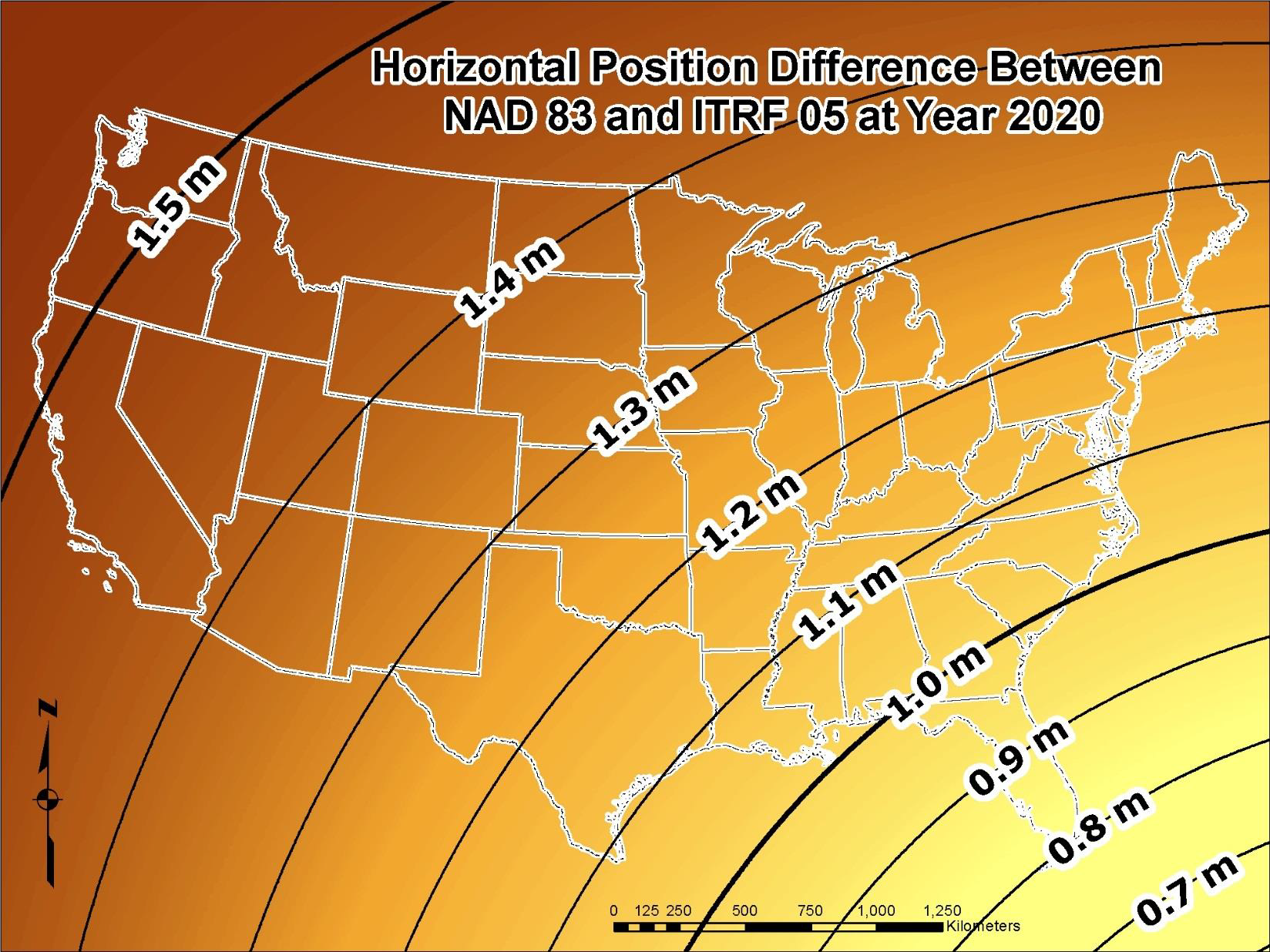
Image excerpted from the National Oceanic and Atmospheric Administration website
Because of poor geographic coverage of the IGS-tracking network in the United States, NGS will propose installation of new GNSS sites, which will be called “Foundation CORS.” There will be approximately 20 when the set is finished.
