Urban Future


Taking the Manhattan core as a starting point, and referencing planning initiatives such as New York’s 2019 Streets Master Plan legislation, as well as analyzing existing and planned pedestrian, cycling, and transit networks, the proposal envisions a network of superblock modules, each consisting of eight Manhattan blocks. As in Barcelona, through-traffic is held to the perimeter, where dedicated bus- and bikeways enhance connectivity. Interior streets are designed as slow streets where vehicle access is limited to local traffic, with the central interior roadway becoming a pedestrian zone that serves as more of a front yard, similar to the Dutch woonerf, or living street. “The superblock model is attractive both for transportation and for creating a community within the grid,” says David Vega-Barachowitz, director of urban design at WXY. He sees the proposal as setting the table for the city administration to think big over the next decade about reallocating street space for more diverse uses, and turning the piecemeal, bottom-up initiatives of the summer of 2020 into a coherent transformation that advances the city’s long-standing goals.
Experience with unrelated temporary street modifications during the pandemic can help inform the phased rollout of a more comprehensive plan. One of the most significant insights to emerge from a WXY initiative—to create a series of parklets, curbside activations, and covered structures along the sidewalk of Strivers Row in Harlem—pertains to the process of designing, constructing, and operating a project that’s relevant and meaningful to the community, says Vega-Barachowitz. “Neighborhood partners play a critical role, not just in creating a design vision and an ideal spatial hierarchy, but in creating the place,” he says. While that experience shows that success depends on strong local organizations to helm the process and follow through, it raises the need to ensure that a lack of such organizational capacity to maintain public space does not become a barrier to equitable distribution of such desirable new spaces throughout the city.
WXY is continuing to develop the superblock proposal in collaboration with Sam Schwartz Engineering, and is working with advocacy partners to disseminate the vision to stakeholders across the city. With a new Department of Transportation (DOT) commissioner for the municipality and strong New York representation at the federal DOT, Vega-Barachowitz says the group sees a strategic opportunity to accelerate this kind of vision and to realize pilots and capital projects that will further its goals.
One of the central challenges of transforming a streetscape entails balancing the needs of multiple users and functions in a limited road-width. Designing for the ability to serve different uses at different times can help optimize streets and enhance their value to the community. For example, a curbside lane might serve as a dedicated busway during morning rush hours, become a midday greenway (with adjacent rain or community gardens) to facilitate neighborhood connections to parks or waterfronts via bike and other micro-mobility modes, and combine with adjacent lanes in the evenings or on weekends to allow for outdoor eating, recreation, or festivals.
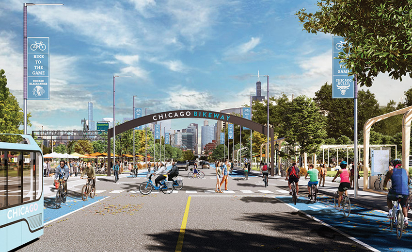
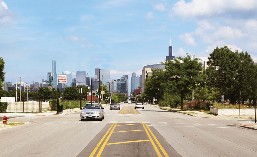
IMAGES: © SOM
For Chicago, SOM and City Tech Collabo-rative pro-pose transforming Chica--go’s roadways, including Madison Street, on the West Side, from multi-lane arteries for cars (bottom) into space that could better accommodate cyclists, pedestrians,
and public transit (top).
An emerging concept supporting this type of flexibility is the modular lane, says Francesco Cerroni, mobility leader at Buro Happold, where the idea is being developed. Modular lanes use low-tech solutions like pavement markings and colored paint, along with medium-tech tactics including pavement-embedded lighting and hydraulic bollards. Innovations such as internet-connected sensors and smart curbs (where technology can enhance the varied and efficient use of in-demand zones) can also contribute. Such designation and information strategies, all of which now exist in various stages of use, allow modular lanes to be activated on demand, and modified with the season, day, or hour. “With good management of these elements,” says Cerroni, “we can create a successful story for redistributing and reusing the street space.”
As the technology of transportation advances, experts widely agree that it should be employed to facilitate good design rather than vice versa. SOM and the technology-based innovation nonprofit City Tech Collaborative recently teamed up to develop a set of ideas, with input from multiple stakeholders, on how streets in Chicago could evolve over the next 10 to 30 years. Design concepts, modeled on that city’s typical street types, take account of new technologies such as access to real-time information on personal devices about transit service and on-demand cars; innovations in equipment, like autonomous vehicles and faster telecommunications; mobility trends, including electrification and the rise of micro-transit; and functional priorities: freight and logistics, public transit, personal vehicles, cycling, and walking. Arising from these considerations come a set of predictions, strategies, components, and case studies for tailoring solutions to neighborhood conditions. While the study doesn’t take Covid into account explicitly, “resilience depends on flexibility and adaptability, which are relevant to a pandemic as well as other stressors,” says Christopher Hall, urban-strategy leader in SOM’s City Design Practice.
Besides the future function of Chicago’s streets, SOM is also considering the city as a whole. Looking at mapping and overlays of the greenways and boulevards that were part of Daniel Burnham’s influential 1909 Plan of Chicago (which was only partially implemented), “you start to see a green weave emerge that could put everyone in Chicago within a five- to ten-minute bike ride of a park,” says Doug Voigt, head of SOM’s City Design Practice. Using the city’s boulevards and abandoned rail lines this way could quickly mitigate Chicago’s inequities around access to green space and build on the city’s pandemic responses by adding connections to its centralized, radial mobility network. The “green weave” would also incorporate stormwater management and improved habitat, adding further value to the public realm.
These ideas are influencing government decisions regarding ongoing city-led rail and trail initiatives, as well as the use and quality of streets as public spaces in response to the pandemic, Hall and Voigt say. The research is also expected to inform discussions about how anticipated federal infrastructure funding could be used to develop Chicago’s streets.
During Covid-19, street changes have happened fast, and they’ve provided momentum for long-term change. Significant proposals like the ones from Toronto, New York, and Chicago are raising awareness of fresh possibilities and priorities for underserved neighborhoods. “The pandemic has brought to the fore the appreciation and understanding of how important our streets are to the livability of our communities,” says Hall. All of which makes this an exciting time in the history of streets—and for anyone with a reason for crossing them.
Supplemental Material
Streets for Pandemic Response & Recovery, NACTO and Global Designing Cities Initiative
| Architectural Record is the #1 source for design news, architect continuing education, and info on sustainability, houses, projects, and architectural products. |
