Urban Future


In Toronto’s core, one of the biggest issues is the lack of public open space. By the measure of the World Health Organization, green space per person falls far short of the minimum recommended 9 square meters—never mind the ideal of 50. During the short summer, thousands of Torontonians who wanted to be outside gathered unsafely in the downtown’s few small parks. With land for new ones scarce, “if city living is going to be relevant, competitive, and attractive post-Covid,” says Adam Nicklin, a principal at the local urban-design and landscape-architecture firm PUBLIC WORK, “you have to rethink the role of streets.”
IMAGES: © WXY; PUBLIC WORK
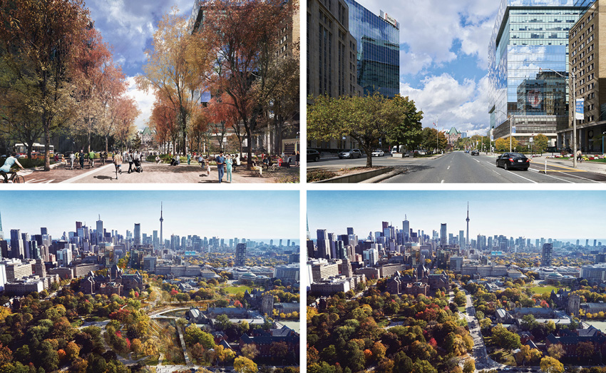
The scheme for Toronto’s University Avenue would create a 90-acre linear park with Queen’s Park (existing, bottom right; proposed, bottom left) at one end and Lake Ontario at the other. It would connect civic and cultural institutions and pass through the hospital district (existing, top right; proposed, left).
PUBLIC WORK has made a bold proposal, with sponsorship from the Michael Young Family Foundation and the urban-sustainability nonprofit Evergreen, to re-envision University Avenue, one of Toronto’s major north–south thoroughfares, as a civic promenade. The plan would consolidate six to eight lanes of vehicular traffic into four lanes on the western side, convert the eastern lanes to bike and pedestrian paths, and use ecological landscaping to link isolated patches of public green space along the route. The concept means taking just 9.5 acres of city-owned asphalt to create a 90-acre linear park. At its north end, the new University Park would connect the provincial parliament, the University of Toronto, and significant cultural institutions. Continuing south through the city’s hospital district, with much-needed places of green respite, it would pass the law courts and adjacent city hall, and finish at the shore of Lake Ontario.
The proposal also calls for the installation of green infrastructure to help mitigate the city’s increasingly severe flooding, and for the acknowledgement of indigenous landscape elements, such as a buried creek, in counterpoint to the colonial memorials that now dot the boulevard.
In addition to improving the quality of life in Toronto’s vertical neighborhoods, the project acknowledges the significance of University Avenue as the site for public protest and demonstration. “In this past year, more than ever before, we have realized the need for gathering places where people can raise their voice,” says Nina Pesavento, project lead for the Young foundation. With the provincial parliament and city hall, University Avenue is the street most symbolic of democracy in Toronto, Nicklin notes. Transforming it into a welcoming public space at the heart of the city, open to all, acknowledges the importance of street space in an equitable society.
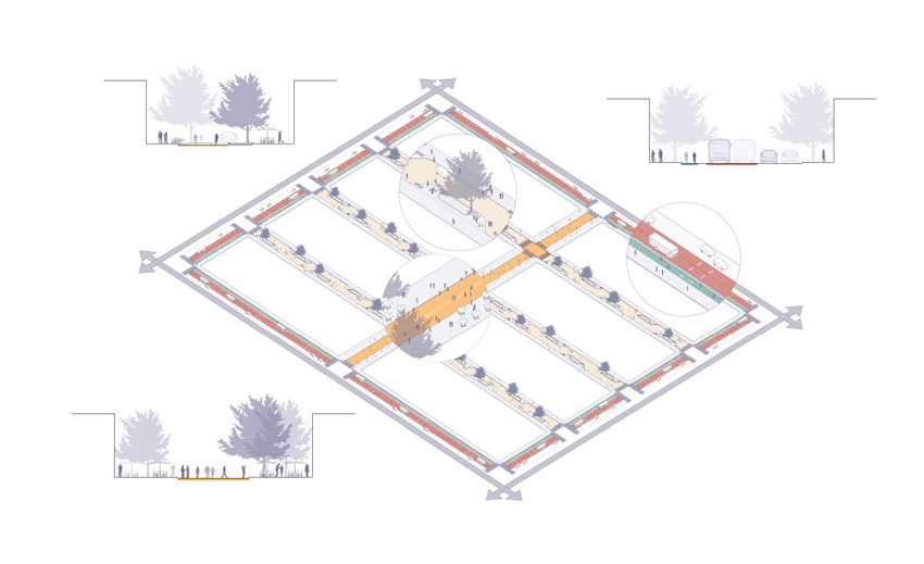
The Superblock concept that WXY has put forward for Manhattan is based on an eight-block grid. Interior streets would be limited to local traffic, with a central spine for pedestrians.
The proposal has attracted significant public and planning interest, and the mayor has recently convened a panel to study its feasibility. At a projected cost of just $215 million, and buildable in an estimated five years, in coordination with infrastructure upgrades scheduled to tear up the pavement in 2024 anyway, the project goes after low-hanging fruit, says Nicklin. “Instead of fragmented and disparate little pockets of unrelated land, you have—yes, a street—but also a massive civic park, a ceremonial space, a gathering place, a health district,” he says. “And it doesn’t have any magic tricks up its sleeve, other than just taking what you have and changing the way it works.”
A similar approach underlies a grand vision for Manhattan based on the superblock concept that Barcelona has been pioneering to wide acclaim (ARCHITECTURAL RECORD, June 2019). Not to be confused with the disconnected and monolithic superblocks of the mid-20th century that Jane Jacobs decried in The Death and Life of Great American Cities, the Barcelona model creates nine-block squares of traffic-calmed and shared streets, with transit connections and through-traffic at the perimeters. In 2016, WXY Architecture + Urban Design floated an idea for how the concept might be adapted for 30 or so blocks in New York’s financial district; in 2018, designers at Perkins Eastman made a case for applying the idea to the Manhattan grid more broadly. Most recently, WXY’s extrapolations from the city’s swiftly implemented pandemic programs, such as Open Streets and Open Restaurants, have led them to consider longer-term objectives—including climate response, equity, and traffic safety, as well as public health—and reintroduce the superblock concept.
